


Lentisques - Pic d’Aurelle

GeorgesV.
User
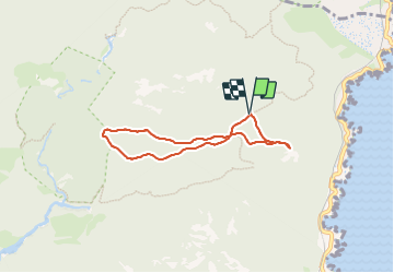

Length
5.9 km

Max alt
295 m

Uphill gradient
115 m
Km-Effort
7.4 km

Min alt
234 m

Downhill gradient
114 m
Boucle
Yes
Creation date :
2023-12-11 08:02:54.0
Updated on :
2023-12-11 10:10:49.836

FREE GPS app for hiking
 SityTrail
IGN / Geographical institutes
SityTrail Plus
The world is yours!
About
Trail of 5.9 km to be discovered at Provence-Alpes-Côte d'Azur, Var, Saint-Raphaël. This trail is proposed by GeorgesV..
Description
Belle randonnée de 6 km et 150 m de D
Sentiers en balcon, jolis points de vue.
Positioning
Country:
France
Region :
Provence-Alpes-Côte d'Azur
Department/Province :
Var
Municipality :
Saint-Raphaël
Location:
Unknown
Start:(Dec)
Start:(UTM)
330834 ; 4815143 (32T) N.
Comments