


randonnée de l extrême ☺️ 1ere partie

Pascal84
User
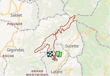

Length
21 km

Max alt
725 m

Uphill gradient
877 m
Km-Effort
32 km

Min alt
194 m

Downhill gradient
886 m
Boucle
Yes
Creation date :
2023-12-11 08:41:27.17
Updated on :
2023-12-11 18:39:14.276
7h10
Difficulty : Very difficult

FREE GPS app for hiking
 SityTrail
IGN / Geographical institutes
SityTrail Plus
The world is yours!
About
Trail Walking of 21 km to be discovered at Provence-Alpes-Côte d'Azur, Vaucluse, Lafare. This trail is proposed by Pascal84.
Positioning
Country:
France
Region :
Provence-Alpes-Côte d'Azur
Department/Province :
Vaucluse
Municipality :
Lafare
Location:
Unknown
Start:(Dec)
Start:(UTM)
663871 ; 4891152 (31T) N.
Comments