


Spiennes

BOUMA
User
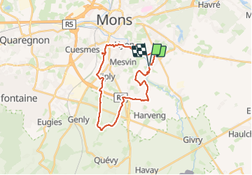

Length
24 km

Max alt
119 m

Uphill gradient
342 m
Km-Effort
29 km

Min alt
36 m

Downhill gradient
342 m
Boucle
Yes
Creation date :
2023-12-12 08:02:59.125
Updated on :
2023-12-12 14:30:35.225
5h01
Difficulty : Medium

FREE GPS app for hiking
 SityTrail
IGN / Geographical institutes
SityTrail Plus
The world is yours!
About
Trail Nordic walking of 24 km to be discovered at Wallonia, Hainaut, Mons. This trail is proposed by BOUMA.
Positioning
Country:
Belgium
Region :
Wallonia
Department/Province :
Hainaut
Municipality :
Mons
Location:
Unknown
Start:(Dec)
Start:(UTM)
570099 ; 5586417 (31U) N.
Comments