


2023-12-12_17h58m28_A28

LUTZMarc
User
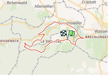

Length
14.7 km

Max alt
435 m

Uphill gradient
350 m
Km-Effort
19.4 km

Min alt
215 m

Downhill gradient
350 m
Boucle
Yes
Creation date :
2023-12-12 16:58:28.512
Updated on :
2023-12-12 17:19:14.445
4h24
Difficulty : Very difficult

FREE GPS app for hiking
 SityTrail
IGN / Geographical institutes
SityTrail Plus
The world is yours!
About
Trail Walking of 14.7 km to be discovered at Grand Est, Bas-Rhin, Cosswiller. This trail is proposed by LUTZMarc.
Positioning
Country:
France
Region :
Grand Est
Department/Province :
Bas-Rhin
Municipality :
Cosswiller
Location:
Unknown
Start:(Dec)
Start:(UTM)
382382 ; 5387628 (32U) N.
Comments