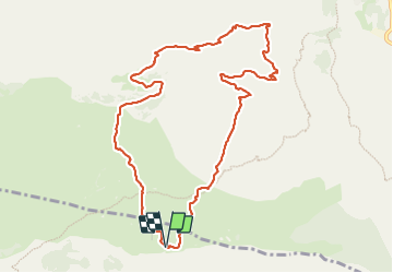
Trail Walking Caussols - Calern - Photo
 Renefrt
Renefrt

User

© OpenStreetMap contributors
Length
Length
11.2 km
Max alt
Max alt
1271 m
Uphill gradient
Uphill gradient
378 m
Km-Effort
Km-Effort  
16.2 km
Min alt
Min alt
945 m
Downhill gradient
Downhill gradient
378 m
Boucle
Boucle
Yes
Creation date :
2023-12-07 07:59:51.0
Updated on :
2023-12-14 05:40:15.786

(0 Reviews)

Walking
Walking
5h56
Difficulty : Medium

Scan this QR Code to open this trail in the SityTrail application

FREE GPS app for hiking

Logo SityTrail SityTrail

IGN / Geographical institutes

Download SityTrail from the App Store Download SityTrail from Google Play

Logo SityTrail SityTrail Plus

The world is yours!

Download SityTrail from the App Store Download SityTrail from Google Play Download SityTrail on Huawei AppGallery

About

Trail Walking of 11.2 km to be discovered at Provence-Alpes-Côte d'Azur, Maritime Alps, Caussols. This trail is proposed by Renefrt.

Description

Aussi agréable au printemps automne qu’en hiver.

Si ce n’est quelques cabanes de bergers on se croirait sur une autre planète.

Comme on le dit tous les chemins ou travers du plateau ramènent au parking. Pas grave si on ne suit pas la trace.

Elevation profile

Photos

Positioning

Country:
France
Region :
Provence-Alpes-Côte d'Azur
Department/Province :
Maritime Alps
Municipality :
Caussols
Location:
Unknown
Start:(UTM)
332866 ; 4846366 (32T) N.


Close
My subscriptions