


Locquirec

taguette
User
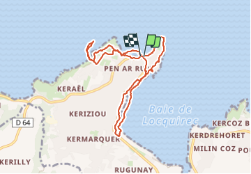

Length
8.4 km

Max alt
52 m

Uphill gradient
151 m
Km-Effort
10.4 km

Min alt
0 m

Downhill gradient
152 m
Boucle
Yes
Creation date :
2023-12-13 09:42:00.498
Updated on :
2023-12-13 17:12:48.479
2h15
Difficulty : Very easy

FREE GPS app for hiking
 SityTrail
IGN / Geographical institutes
SityTrail Plus
The world is yours!
About
Trail Walking of 8.4 km to be discovered at Brittany, Finistère, Locquirec. This trail is proposed by taguette.
Positioning
Country:
France
Region :
Brittany
Department/Province :
Finistère
Municipality :
Locquirec
Location:
Unknown
Start:(Dec)
Start:(UTM)
452275 ; 5393582 (30U) N.
Comments