


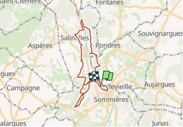
Moulin Sommieres

JMJ42
User

Length
16.7 km

Max alt
96 m

Uphill gradient
218 m
Km-Effort
19.6 km

Min alt
23 m

Downhill gradient
218 m
Boucle
Yes
Creation date :
2023-12-12 08:40:26.708
Updated on :
2023-12-13 21:54:02.551
4h48
Difficulty : Medium

FREE GPS app for hiking
 SityTrail
IGN / Geographical institutes
SityTrail Plus
The world is yours!
About
Trail Walking of 16.7 km to be discovered at Occitania, Gard, Sommières. This trail is proposed by JMJ42.
Positioning
Country:
France
Region :
Occitania
Department/Province :
Gard
Municipality :
Sommières
Location:
Unknown
Start:(Dec)
Start:(UTM)
587106 ; 4848934 (31T) N.
Comments