


boucle wingen

LUTZMarc
User
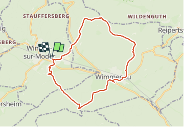

Length
15.8 km

Max alt
341 m

Uphill gradient
370 m
Km-Effort
21 km

Min alt
196 m

Downhill gradient
370 m
Boucle
Yes
Creation date :
2023-12-07 08:20:09.564
Updated on :
2023-12-14 07:09:42.964
3h46
Difficulty : Easy

FREE GPS app for hiking
 SityTrail
IGN / Geographical institutes
SityTrail Plus
The world is yours!
About
Trail Walking of 15.8 km to be discovered at Grand Est, Bas-Rhin, Wingen-sur-Moder. This trail is proposed by LUTZMarc.
Photos

Positioning
Country:
France
Region :
Grand Est
Department/Province :
Bas-Rhin
Municipality :
Wingen-sur-Moder
Location:
Unknown
Start:(Dec)
Start:(UTM)
381298 ; 5419833 (32U) N.
Comments