


Monastère de Chalais depuis le monastère des clarisses

MICDURAND
User
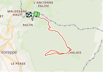

Length
9.2 km

Max alt
1065 m

Uphill gradient
649 m
Km-Effort
17.8 km

Min alt
428 m

Downhill gradient
650 m
Boucle
Yes
Creation date :
2023-12-14 15:00:50.145
Updated on :
2023-12-31 13:32:17.652
4h03
Difficulty : Difficult

FREE GPS app for hiking
 SityTrail
IGN / Geographical institutes
SityTrail Plus
The world is yours!
About
Trail Walking of 9.2 km to be discovered at Auvergne-Rhône-Alpes, Isère, Voreppe. This trail is proposed by MICDURAND.
Positioning
Country:
France
Region :
Auvergne-Rhône-Alpes
Department/Province :
Isère
Municipality :
Voreppe
Location:
Unknown
Start:(Dec)
Start:(UTM)
707787 ; 5020363 (31T) N.
Comments