


Variante

ophness
User
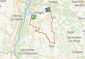

Length
18.1 km

Max alt
227 m

Uphill gradient
152 m
Km-Effort
20 km

Min alt
169 m

Downhill gradient
141 m
Boucle
No
Creation date :
2023-12-15 11:54:51.0
Updated on :
2023-12-15 11:54:52.417

FREE GPS app for hiking
 SityTrail
IGN / Geographical institutes
SityTrail Plus
The world is yours!
About
Trail of 18.1 km to be discovered at Auvergne-Rhône-Alpes, Ain, Cormoranche-sur-Saône. This trail is proposed by ophness.
Positioning
Country:
France
Region :
Auvergne-Rhône-Alpes
Department/Province :
Ain
Municipality :
Cormoranche-sur-Saône
Location:
Unknown
Start:(Dec)
Start:(UTM)
640848 ; 5121936 (31T) N.
Comments