


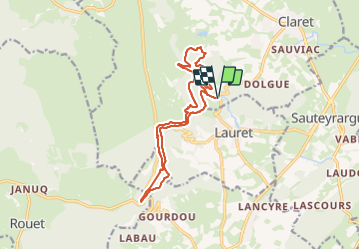
Lauret, les rocs du Causse

34christophe
User

Length
15.3 km

Max alt
400 m

Uphill gradient
423 m
Km-Effort
21 km

Min alt
186 m

Downhill gradient
423 m
Boucle
Yes
Creation date :
2023-12-16 09:28:53.667
Updated on :
2023-12-16 09:34:50.852
5h40
Difficulty : Medium

FREE GPS app for hiking
 SityTrail
IGN / Geographical institutes
SityTrail Plus
The world is yours!
About
Trail Walking of 15.3 km to be discovered at Occitania, Hérault, Claret. This trail is proposed by 34christophe.
Description
rando en ligne de crête des Roc de Lafous, Rocher du Causse, Roc des Mates ; retour par sentier en balcon
Positioning
Country:
France
Region :
Occitania
Department/Province :
Hérault
Municipality :
Claret
Location:
Unknown
Start:(Dec)
Start:(UTM)
570672 ; 4854814 (31T) N.
Comments