


Chartreuse Rocher de la Garde

c.gourme
User
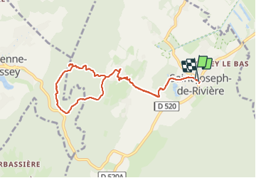

Length
9.4 km

Max alt
706 m

Uphill gradient
376 m
Km-Effort
14.4 km

Min alt
405 m

Downhill gradient
373 m
Boucle
Yes
Creation date :
2023-12-16 08:13:31.0
Updated on :
2023-12-16 11:53:24.149

FREE GPS app for hiking
 SityTrail
IGN / Geographical institutes
SityTrail Plus
The world is yours!
About
Trail of 9.4 km to be discovered at Auvergne-Rhône-Alpes, Isère, Saint-Joseph-de-Rivière. This trail is proposed by c.gourme.
Positioning
Country:
France
Region :
Auvergne-Rhône-Alpes
Department/Province :
Isère
Municipality :
Saint-Joseph-de-Rivière
Location:
Unknown
Start:(Dec)
Start:(UTM)
711085 ; 5028243 (31T) N.
Comments