


20241217 Chuines

Jeanclaudebic
User

Length
13.2 km

Max alt
210 m

Uphill gradient
110 m
Km-Effort
14.6 km

Min alt
160 m

Downhill gradient
109 m
Boucle
Yes
Creation date :
2023-12-17 12:44:36.887
Updated on :
2023-12-17 15:50:52.412
2h34
Difficulty : Difficult

FREE GPS app for hiking
 SityTrail
IGN / Geographical institutes
SityTrail Plus
The world is yours!
About
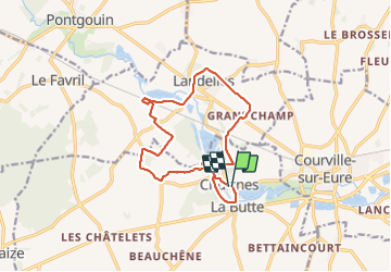
Trail Walking of 13.2 km to be discovered at Centre-Loire Valley, Eure-et-Loir, Chuisnes. This trail is proposed by Jeanclaudebic.
Positioning
Country:
France
Region :
Centre-Loire Valley
Department/Province :
Eure-et-Loir
Municipality :
Chuisnes
Location:
Unknown
Start:(Dec)
Start:(UTM)
367582 ; 5367477 (31U) N.
Comments