


Hourquette Ancizan

chasle
User
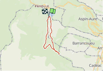

Length
11.1 km

Max alt
1565 m

Uphill gradient
442 m
Km-Effort
17 km

Min alt
1149 m

Downhill gradient
443 m
Boucle
Yes
Creation date :
2023-12-17 07:59:28.491
Updated on :
2023-12-17 16:22:41.785
3h52
Difficulty : Difficult
0m
Difficulty : Medium

FREE GPS app for hiking
 SityTrail
IGN / Geographical institutes
SityTrail Plus
The world is yours!
About
Trail Walking of 11.1 km to be discovered at Occitania, Hautespyrenees, Arreau. This trail is proposed by chasle.
Positioning
Country:
France
Region :
Occitania
Department/Province :
Hautespyrenees
Municipality :
Arreau
Location:
Unknown
Start:(Dec)
Start:(UTM)
279156 ; 4756862 (31T) N.
Comments