


BEZOT 18_12-2023

nordan
User
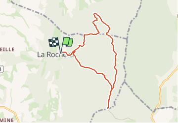

Length
8.3 km

Max alt
640 m

Uphill gradient
379 m
Km-Effort
13.4 km

Min alt
408 m

Downhill gradient
377 m
Boucle
Yes
Creation date :
2023-12-17 13:08:47.576
Updated on :
2023-12-19 10:20:56.763
2h08
Difficulty : Medium

FREE GPS app for hiking
 SityTrail
IGN / Geographical institutes
SityTrail Plus
The world is yours!
About
Trail Walking of 8.3 km to be discovered at Auvergne-Rhône-Alpes, Drôme, Vaunaveys-la-Rochette. This trail is proposed by nordan.
Positioning
Country:
France
Region :
Auvergne-Rhône-Alpes
Department/Province :
Drôme
Municipality :
Vaunaveys-la-Rochette
Location:
Unknown
Start:(Dec)
Start:(UTM)
661978 ; 4961547 (31T) N.
Comments