


vlt1002L

jmheydorff
User
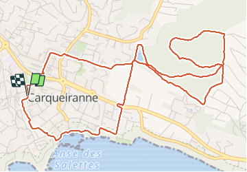

Length
8.2 km

Max alt
202 m

Uphill gradient
220 m
Km-Effort
11.1 km

Min alt
0 m

Downhill gradient
219 m
Boucle
Yes
Creation date :
2023-12-18 13:01:50.568
Updated on :
2023-12-20 09:51:08.346
2h31
Difficulty : Medium

FREE GPS app for hiking
 SityTrail
IGN / Geographical institutes
SityTrail Plus
The world is yours!
About
Trail Walking of 8.2 km to be discovered at Provence-Alpes-Côte d'Azur, Var, Carqueiranne. This trail is proposed by jmheydorff.
Positioning
Country:
France
Region :
Provence-Alpes-Côte d'Azur
Department/Province :
Var
Municipality :
Carqueiranne
Location:
Unknown
Start:(Dec)
Start:(UTM)
261724 ; 4775108 (32T) N.
Comments