


2023-12-21_07h41m24_D5

LUTZMarc
User
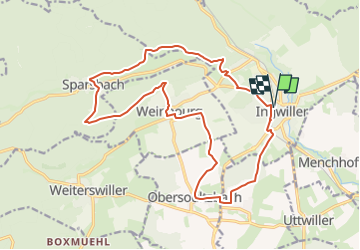

Length
18.3 km

Max alt
326 m

Uphill gradient
387 m
Km-Effort
23 km

Min alt
189 m

Downhill gradient
387 m
Boucle
Yes
Creation date :
2023-12-21 06:41:24.44
Updated on :
2024-11-01 09:01:36.983
5h19
Difficulty : Easy

FREE GPS app for hiking
 SityTrail
IGN / Geographical institutes
SityTrail Plus
The world is yours!
About
Trail Walking of 18.3 km to be discovered at Grand Est, Bas-Rhin, Ingwiller. This trail is proposed by LUTZMarc.
Description
Resto au Bois flotté à Weinbourg
Positioning
Country:
France
Region :
Grand Est
Department/Province :
Bas-Rhin
Municipality :
Ingwiller
Location:
Unknown
Start:(Dec)
Start:(UTM)
388338 ; 5414426 (32U) N.
Comments