


saubens petit tour 2023

pidjam
User
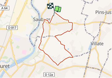

Length
7.7 km

Max alt
203 m

Uphill gradient
65 m
Km-Effort
8.5 km

Min alt
161 m

Downhill gradient
65 m
Boucle
Yes
Creation date :
2023-12-21 13:00:04.053
Updated on :
2023-12-21 14:42:32.398
1h39
Difficulty : Easy

FREE GPS app for hiking
 SityTrail
IGN / Geographical institutes
SityTrail Plus
The world is yours!
About
Trail Walking of 7.7 km to be discovered at Occitania, Haute-Garonne, Saubens. This trail is proposed by pidjam.
Positioning
Country:
France
Region :
Occitania
Department/Province :
Haute-Garonne
Municipality :
Saubens
Location:
Unknown
Start:(Dec)
Start:(UTM)
366924 ; 4815439 (31T) N.
Comments