


Colombier Fontanas

Papou63patrick
User
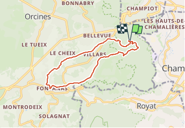

Length
6.8 km

Max alt
792 m

Uphill gradient
203 m
Km-Effort
9.5 km

Min alt
596 m

Downhill gradient
205 m
Boucle
Yes
Creation date :
2023-12-22 12:54:28.613
Updated on :
2023-12-22 14:48:43.09
1h53
Difficulty : Easy

FREE GPS app for hiking
 SityTrail
IGN / Geographical institutes
SityTrail Plus
The world is yours!
About
Trail Walking of 6.8 km to be discovered at Auvergne-Rhône-Alpes, Puy-de-Dôme, Orcines. This trail is proposed by Papou63patrick.
Photos

Positioning
Country:
France
Region :
Auvergne-Rhône-Alpes
Department/Province :
Puy-de-Dôme
Municipality :
Orcines
Location:
Unknown
Start:(Dec)
Start:(UTM)
503289 ; 5069564 (31T) N.
Comments