


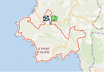
St Cyr - Port d'Allon

Vox463
User

Length
14.7 km

Max alt
163 m

Uphill gradient
435 m
Km-Effort
20 km

Min alt
6 m

Downhill gradient
435 m
Boucle
Yes
Creation date :
2023-12-23 17:50:32.07
Updated on :
2023-12-23 17:51:39.152
4h39
Difficulty : Very difficult

FREE GPS app for hiking
 SityTrail
IGN / Geographical institutes
SityTrail Plus
The world is yours!
About
Trail Walking of 14.7 km to be discovered at Provence-Alpes-Côte d'Azur, Var, Saint-Cyr-sur-Mer. This trail is proposed by Vox463.
Positioning
Country:
France
Region :
Provence-Alpes-Côte d'Azur
Department/Province :
Var
Municipality :
Saint-Cyr-sur-Mer
Location:
Unknown
Start:(Dec)
Start:(UTM)
719784 ; 4782123 (31T) N.
Comments