


SURCENEUX XONRUPT LONGEMER

surceneux
User
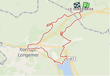

Length
9.9 km

Max alt
882 m

Uphill gradient
227 m
Km-Effort
13 km

Min alt
718 m

Downhill gradient
228 m
Boucle
Yes
Creation date :
2023-12-24 08:04:46.422
Updated on :
2023-12-24 12:22:26.206
1h55
Difficulty : Easy

FREE GPS app for hiking
 SityTrail
IGN / Geographical institutes
SityTrail Plus
The world is yours!
About
Trail Walking of 9.9 km to be discovered at Grand Est, Vosges, Ban-sur-Meurthe-Clefcy. This trail is proposed by surceneux.
Description
SURCENEUX XONRUPT LONGEMER VIA LE LAC RETOUR PAR LES FIES BEHEUILLE
Positioning
Country:
France
Region :
Grand Est
Department/Province :
Vosges
Municipality :
Ban-sur-Meurthe-Clefcy
Location:
Unknown
Start:(Dec)
Start:(UTM)
347876 ; 5329048 (32U) N.
Comments