


faute- Roybon

lionelnottat
User
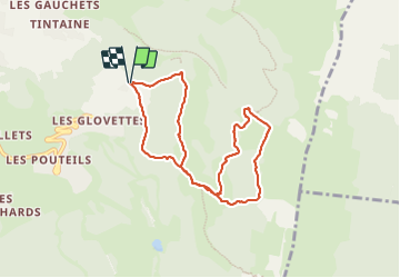

Length
8.2 km

Max alt
1539 m

Uphill gradient
363 m
Km-Effort
13.1 km

Min alt
1237 m

Downhill gradient
364 m
Boucle
Yes
Creation date :
2023-12-26 09:45:16.312
Updated on :
2023-12-26 13:27:33.445
2h31
Difficulty : Difficult

FREE GPS app for hiking
 SityTrail
IGN / Geographical institutes
SityTrail Plus
The world is yours!
About
Trail Walking of 8.2 km to be discovered at Auvergne-Rhône-Alpes, Isère, Villard-de-Lans. This trail is proposed by lionelnottat.
Positioning
Country:
France
Region :
Auvergne-Rhône-Alpes
Department/Province :
Isère
Municipality :
Villard-de-Lans
Location:
Unknown
Start:(Dec)
Start:(UTM)
702219 ; 4992378 (31T) N.
Comments