Trail Motorbike Birieux - Moto - Photo
© OpenStreetMap contributors
Length
Length
45 km
Max alt
Max alt
299 m
Uphill gradient
Uphill gradient
436 m
Km-Effort
Km-Effort  
51 km
Min alt
Min alt
217 m
Downhill gradient
Downhill gradient
436 m
Boucle
Boucle
Yes
Creation date :
2023-12-27 13:08:13.0
Updated on :
2023-12-27 14:16:45.129

(0 Reviews)

Motorbike
Motorbike
54m
Difficulty : Medium

Scan this QR Code to open this trail in the SityTrail application

FREE GPS app for hiking

Logo SityTrail SityTrail

IGN / Geographical institutes

Download SityTrail from the App Store Download SityTrail from Google Play

Logo SityTrail SityTrail World

The world is yours!

Download SityTrail from the App Store Download SityTrail from Google Play Download SityTrail on Huawei AppGallery

About

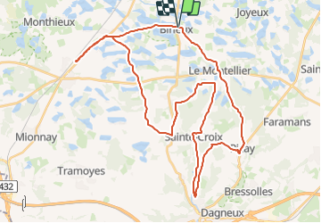
Trail Motorbike of 45 km to be discovered at Auvergne-Rhône-Alpes, Ain, Birieux. This trail is proposed by frederic@comby.eu.

Description

27/12/2023 moto

Elevation profile

Positioning

Country:
France
Region :
Auvergne-Rhône-Alpes
Department/Province :
Ain
Municipality :
Birieux
Location:
Unknown
Start:(UTM)
658180 ; 5090965 (31T) N.

Trails nearby

Trail Walking Joyeux - 11 lacs dans les Dombes. - Photo
Walking
pffrench

Walking

Very easy
(2)
Joyeux, Auvergne-Rhône-Alpes, Ain, France
11 km | 12.1 km-effort
2h 57min
Yes
Trail Walking Le Montellier - LES ONZES ETANGS - Photo
Walking
JBARDIN

Walking

Very easy
(3)
Le Montellier, Auvergne-Rhône-Alpes, Ain, France
10.5 km | 11.5 km-effort
Unknown
Yes
Trail Walking Saint-Marcel - 01-st-Marcel-Birieux-20km-140m-dec21 - Photo
Walking
SyMA

Walking

Medium
Saint-Marcel, Auvergne-Rhône-Alpes, Ain, France
20 km | 22 km-effort
5h 14min
Yes
Trail Walking Saint-Marcel - 01-St-Marcel-Birieux-resto-19km-140m - Photo
Walking
SyMA

Walking

Easy
Saint-Marcel, Auvergne-Rhône-Alpes, Ain, France
19.3 km | 21 km-effort
5h 54min
Yes
Trail Walking Saint-Marcel - st Marcel en Dombes 12.9 2021 - Photo
Walking
maclobar

Walking

Difficult
Saint-Marcel, Auvergne-Rhône-Alpes, Ain, France
13.7 km | 14.8 km-effort
3h 0min
Yes
Trail Walking Le Montellier - Chateau de Montellier 11 Etangs - Photo
Walking
0660719777

Walking

Difficult
Le Montellier, Auvergne-Rhône-Alpes, Ain, France
11.7 km | 12.7 km-effort
5h 1min
Yes
Trail Road bike Versailleux - versailleux dombe - Photo
Road bike
Acy1959

Road bike

Very easy
Versailleux, Auvergne-Rhône-Alpes, Ain, France
75 km | 86 km-effort
4h 19min
Yes
Trail Walking Joyeux - Joyeux - Photo
Walking
Val Cha

Walking

Very easy
Joyeux, Auvergne-Rhône-Alpes, Ain, France
10.3 km | 11.3 km-effort
2h 28min
Yes
Trail Walking Le Montellier - Joyeux - Photo
Walking
Val Cha

Walking

Easy
Le Montellier, Auvergne-Rhône-Alpes, Ain, France
10.5 km | 11.5 km-effort
2h 48min
Yes


Close
My subscriptions