


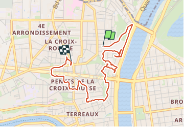
Circuit Croix Rousse

Marie-Hélène Luton 2
User

Length
4.8 km

Max alt
263 m

Uphill gradient
215 m
Km-Effort
7.6 km

Min alt
176 m

Downhill gradient
207 m
Boucle
No
Creation date :
2023-12-27 13:25:33.804
Updated on :
2023-12-27 16:36:42.478
2h40
Difficulty : Medium

FREE GPS app for hiking
 SityTrail
IGN / Geographical institutes
SityTrail Plus
The world is yours!
About
Trail Walking of 4.8 km to be discovered at Auvergne-Rhône-Alpes, Métropole de Lyon, Lyon. This trail is proposed by Marie-Hélène Luton 2.
Description
Circuit autour de la Croix rousse via les escaliers.
Positioning
Country:
France
Region :
Auvergne-Rhône-Alpes
Department/Province :
Métropole de Lyon
Municipality :
Lyon
Location:
Lyon 4e Arrondissement
Start:(Dec)
Start:(UTM)
642728 ; 5070848 (31T) N.
Comments