


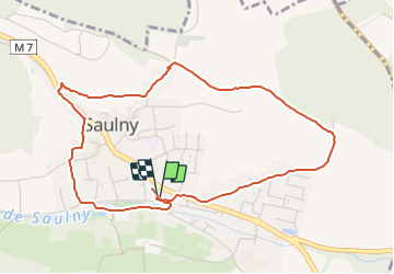
Course Saulny 281223

beckerse
User

Length
4.7 km

Max alt
290 m

Uphill gradient
97 m
Km-Effort
6 km

Min alt
206 m

Downhill gradient
99 m
Boucle
Yes
Creation date :
2023-12-28 09:01:53.123
Updated on :
2023-12-28 09:41:50.259
39m
Difficulty : Easy

FREE GPS app for hiking
 SityTrail
IGN / Geographical institutes
SityTrail Plus
The world is yours!
About
Trail Running of 4.7 km to be discovered at Grand Est, Moselle, Saulny. This trail is proposed by beckerse.
Positioning
Country:
France
Region :
Grand Est
Department/Province :
Moselle
Municipality :
Saulny
Location:
Unknown
Start:(Dec)
Start:(UTM)
289296 ; 5448822 (32U) N.
Comments