


Tarsimoure

oliviergau
User
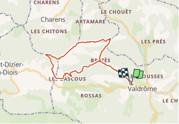

Length
16.7 km

Max alt
1537 m

Uphill gradient
817 m
Km-Effort
28 km

Min alt
814 m

Downhill gradient
811 m
Boucle
Yes
Creation date :
2023-11-19 08:04:38.738
Updated on :
2023-12-29 15:40:16.435
5h44
Difficulty : Very difficult

FREE GPS app for hiking
 SityTrail
IGN / Geographical institutes
SityTrail Plus
The world is yours!
About
Trail Walking of 16.7 km to be discovered at Auvergne-Rhône-Alpes, Drôme, Valdrôme. This trail is proposed by oliviergau.
Positioning
Country:
France
Region :
Auvergne-Rhône-Alpes
Department/Province :
Drôme
Municipality :
Valdrôme
Location:
Unknown
Start:(Dec)
Start:(UTM)
703818 ; 4931257 (31T) N.
Comments