


la frette

sedrix
User
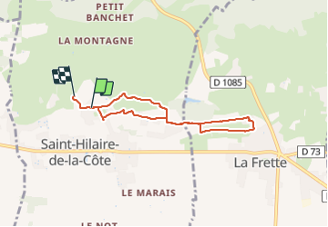

Length
6.4 km

Max alt
464 m

Uphill gradient
135 m
Km-Effort
8.1 km

Min alt
408 m

Downhill gradient
117 m
Boucle
No
Creation date :
2023-12-30 08:53:30.167
Updated on :
2023-12-30 10:41:00.044
1h46
Difficulty : Medium

FREE GPS app for hiking
 SityTrail
IGN / Geographical institutes
SityTrail Plus
The world is yours!
About
Trail Walking of 6.4 km to be discovered at Auvergne-Rhône-Alpes, Isère, Saint-Hilaire-de-la-Côte. This trail is proposed by sedrix.
Positioning
Country:
France
Region :
Auvergne-Rhône-Alpes
Department/Province :
Isère
Municipality :
Saint-Hilaire-de-la-Côte
Location:
Unknown
Start:(Dec)
Start:(UTM)
682124 ; 5029599 (31T) N.
Comments