


Course à pied Calais canal

topolino
User
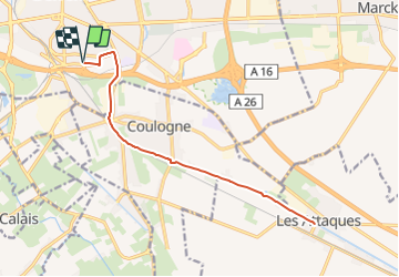

Length
15.3 km

Max alt
7 m

Uphill gradient
66 m
Km-Effort
16.2 km

Min alt
-2 m

Downhill gradient
66 m
Boucle
Yes
Creation date :
2023-12-31 07:34:34.0
Updated on :
2023-12-31 07:34:35.94
0m
Difficulty : Unknown

FREE GPS app for hiking
 SityTrail
IGN / Geographical institutes
SityTrail Plus
The world is yours!
About
Trail Running of 15.3 km to be discovered at Hauts-de-France, Pas-de-Calais, Calais. This trail is proposed by topolino.
Positioning
Country:
France
Region :
Hauts-de-France
Department/Province :
Pas-de-Calais
Municipality :
Calais
Location:
Unknown
Start:(Dec)
Start:(UTM)
419956 ; 5643564 (31U) N.
Comments