Trail Walking Avignon - ile de la Barthelasse - Photo
 nadinebondoux
nadinebondoux

User GUIDE

© OpenStreetMap contributors
Length
Length
13.6 km
Max alt
Max alt
28 m
Uphill gradient
Uphill gradient
90 m
Km-Effort
Km-Effort  
14.8 km
Min alt
Min alt
15 m
Downhill gradient
Downhill gradient
92 m
Boucle
Boucle
Yes
Creation date :
2024-01-03 10:24:22.963
Updated on :
2024-01-03 13:38:57.49

(0 Reviews)

Walking
Walking
3h14
Difficulty : Easy

Scan this QR Code to open this trail in the SityTrail application

FREE GPS app for hiking

Logo SityTrail SityTrail

IGN / Geographical institutes

Download SityTrail from the App Store Download SityTrail from Google Play

Logo SityTrail SityTrail World

The world is yours!

Download SityTrail from the App Store Download SityTrail from Google Play Download SityTrail on Huawei AppGallery

About

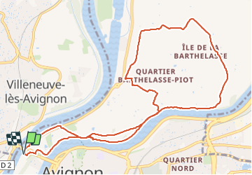
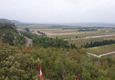
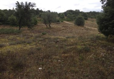
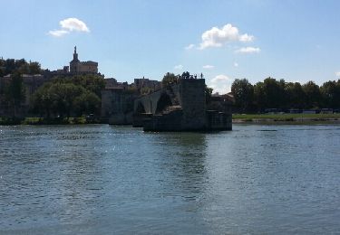
Trail Walking of 13.6 km to be discovered at Provence-Alpes-Côte d'Azur, Vaucluse, Avignon. This trail is proposed by nadinebondoux.

Description

A préférer au printemps

Elevation profile

Photos

Positioning

Country:
France
Region :
Provence-Alpes-Côte d'Azur
Department/Province :
Vaucluse
Municipality :
Avignon
Location:
Unknown
Start:(UTM)
643951 ; 4868162 (31T) N.

Trails nearby

Trail Walking Avignon - ile de Barthelasse 1ere du top 10 des balades d Avignon... pauvres avignonais... - Photo
Walking
stef789

Walking

Very easy
Avignon, Provence-Alpes-Côte d'Azur, Vaucluse, France
8.4 km | 9.2 km-effort
2h 15min
Yes
Trail On foot Avignon - Canal du Puy - 1 - Photo
On foot
PRO

On foot

Easy
Avignon, Provence-Alpes-Côte d'Azur, Vaucluse, France
5.9 km | 6.2 km-effort
1h 24min
Yes
Trail Running Avignon - running hopital - Photo
Running
dreux

Running

Very easy
(1)
Avignon, Provence-Alpes-Côte d'Azur, Vaucluse, France
11.5 km | 12.4 km-effort
1h 5min
No
Trail Walking Villeneuve-lès-Avignon - PF-Villeneuve-les-Avignon - Du chemin des Castors au chemin de Safrus - Photo
Walking
MicDul

Walking

Medium
Villeneuve-lès-Avignon, Occitania, Gard, France
17.2 km | 20 km-effort
4h 4min
Yes
Trail Bicycle tourism Les Angles - Avant dernière étape  - Photo
Bicycle tourism
Denis Remontet

Bicycle tourism

Les Angles, Occitania, Gard, France
39 km | 44 km-effort
3h 47min
No
Trail Mountain bike Villeneuve-lès-Avignon - Rando VTT du Fort Saint André 2018 35km - Photo
Mountain bike
SabetMick

Mountain bike

Medium
Villeneuve-lès-Avignon, Occitania, Gard, France
35 km | 43 km-effort
4h 58min
Yes
Trail Mountain bike Villeneuve-lès-Avignon - Rando VTT de Villeneuve lez Avignon 30 km - Photo
Mountain bike
SabetMick

Mountain bike

Medium
Villeneuve-lès-Avignon, Occitania, Gard, France
30 km | 37 km-effort
3h 43min
Yes
Trail Other activity Villeneuve-lès-Avignon - chemin de perrieres, hauts de Villeneuve - Photo
Other activity
pgranchamp

Other activity

Very easy
Villeneuve-lès-Avignon, Occitania, Gard, France
10 km | 11.8 km-effort
2h 1min
Yes
Trail Walking Avignon - avignon ile de la BARTHELASSE - Photo
Walking
ace003

Walking

Very easy
Avignon, Provence-Alpes-Côte d'Azur, Vaucluse, France
8.4 km | 9.2 km-effort
2h 8min
Yes


Close
My subscriptions