


fontaines en sologne GS 01/2024

mimilolo
User
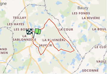

Length
12.4 km

Max alt
116 m

Uphill gradient
95 m
Km-Effort
13.7 km

Min alt
91 m

Downhill gradient
93 m
Boucle
Yes
Creation date :
2024-01-03 17:35:49.169
Updated on :
2024-01-03 17:38:31.623
3h06
Difficulty : Easy

FREE GPS app for hiking
 SityTrail
IGN / Geographical institutes
SityTrail Plus
The world is yours!
About
Trail On foot of 12.4 km to be discovered at Centre-Loire Valley, Loir-et-Cher, Fontaines-en-Sologne. This trail is proposed by mimilolo.
Description
depart parking salle communale
Positioning
Country:
France
Region :
Centre-Loire Valley
Department/Province :
Loir-et-Cher
Municipality :
Fontaines-en-Sologne
Location:
Unknown
Start:(Dec)
Start:(UTM)
390912 ; 5262958 (31T) N.
Comments