


byans

jacthiry
User
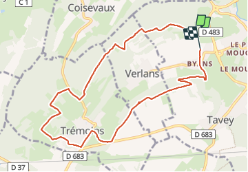

Length
10 km

Max alt
468 m

Uphill gradient
293 m
Km-Effort
13.9 km

Min alt
337 m

Downhill gradient
301 m
Boucle
No
Creation date :
2024-01-04 12:48:42.112
Updated on :
2024-01-04 15:52:07.488
2h39
Difficulty : Difficult

FREE GPS app for hiking
 SityTrail
IGN / Geographical institutes
SityTrail Plus
The world is yours!
About
Trail Walking of 10 km to be discovered at Bourgogne-Franche-Comté, Haute-Saône, Héricourt. This trail is proposed by jacthiry.
Positioning
Country:
France
Region :
Bourgogne-Franche-Comté
Department/Province :
Haute-Saône
Municipality :
Héricourt
Location:
Héricourt
Start:(Dec)
Start:(UTM)
329469 ; 5271842 (32T) N.
Comments