


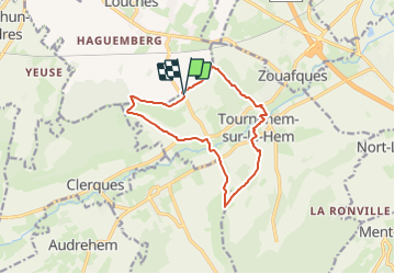
Guémy 11Kms (Dén P 240m)

alain62rando
User

Length
11 km

Max alt
124 m

Uphill gradient
240 m
Km-Effort
14.2 km

Min alt
27 m

Downhill gradient
238 m
Boucle
Yes
Creation date :
2024-01-05 13:37:23.821
Updated on :
2024-01-05 13:38:05.147
3h13
Difficulty : Medium

FREE GPS app for hiking
 SityTrail
IGN / Geographical institutes
SityTrail Plus
The world is yours!
About
Trail Walking of 11 km to be discovered at Hauts-de-France, Pas-de-Calais, Tournehem-sur-la-Hem. This trail is proposed by alain62rando.
Positioning
Country:
France
Region :
Hauts-de-France
Department/Province :
Pas-de-Calais
Municipality :
Tournehem-sur-la-Hem
Location:
Unknown
Start:(Dec)
Start:(UTM)
431070 ; 5629295 (31U) N.
Comments