


de tresilley a villers bouton

gerardmicheline
User
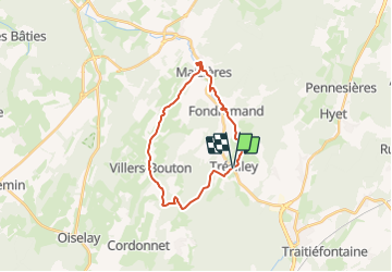

Length
21 km

Max alt
394 m

Uphill gradient
474 m
Km-Effort
27 km

Min alt
237 m

Downhill gradient
474 m
Boucle
Yes
Creation date :
2024-01-05 15:02:47.482
Updated on :
2024-01-05 15:03:28.247
6h10
Difficulty : Very difficult

FREE GPS app for hiking
 SityTrail
IGN / Geographical institutes
SityTrail Plus
The world is yours!
About
Trail Walking of 21 km to be discovered at Bourgogne-Franche-Comté, Haute-Saône, Trésilley. This trail is proposed by gerardmicheline.
Positioning
Country:
France
Region :
Bourgogne-Franche-Comté
Department/Province :
Haute-Saône
Municipality :
Trésilley
Location:
Unknown
Start:(Dec)
Start:(UTM)
276189 ; 5259487 (32T) N.
Comments