


petit parcours 2 Bonnette Experience

laudub
User
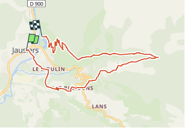

Length
9.9 km

Max alt
1500 m

Uphill gradient
462 m
Km-Effort
16 km

Min alt
1217 m

Downhill gradient
459 m
Boucle
No
Creation date :
2024-01-05 15:10:09.163
Updated on :
2025-02-16 11:27:24.389
0m
Difficulty : Medium

FREE GPS app for hiking
 SityTrail
IGN / Geographical institutes
SityTrail Plus
The world is yours!
About
Trail Trail of 9.9 km to be discovered at Provence-Alpes-Côte d'Azur, Alpes-de-Haute-Provence, Jausiers. This trail is proposed by laudub.

Positioning
Country:
France
Region :
Provence-Alpes-Côte d'Azur
Department/Province :
Alpes-de-Haute-Provence
Municipality :
Jausiers
Location:
Unknown
Start:(Dec)
Start:(UTM)
319641 ; 4920947 (32T) N.
Comments