


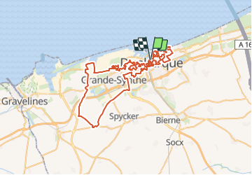
Visite de Dunkerque

mathis01
User

Length
76 km

Max alt
22 m

Uphill gradient
330 m
Km-Effort
80 km

Min alt
-4 m

Downhill gradient
327 m
Boucle
Yes
Creation date :
2024-01-06 07:35:49.936
Updated on :
2024-01-07 09:32:28.875
17h00
Difficulty : Very difficult
3h32
Difficulty : Very difficult

FREE GPS app for hiking
 SityTrail
IGN / Geographical institutes
SityTrail Plus
The world is yours!
About
Trail On foot of 76 km to be discovered at Hauts-de-France, Nord, Dunkirk. This trail is proposed by mathis01.
Positioning
Country:
France
Region :
Hauts-de-France
Department/Province :
Nord
Municipality :
Dunkirk
Location:
Dunkerque
Start:(Dec)
Start:(UTM)
456289 ; 5654167 (31U) N.
Comments