


Chemin des Vioux

Eric Cuny
User

Length
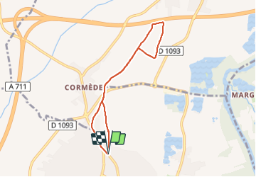
6.5 km

Max alt
367 m

Uphill gradient
57 m
Km-Effort
7.3 km

Min alt
335 m

Downhill gradient
58 m
Boucle
Yes
Creation date :
2024-01-07 12:54:16.733
Updated on :
2024-01-07 14:20:56.655
1h26
Difficulty : Medium

FREE GPS app for hiking
 SityTrail
IGN / Geographical institutes
SityTrail Plus
The world is yours!
About
Trail Walking of 6.5 km to be discovered at Auvergne-Rhône-Alpes, Puy-de-Dôme, Pont-du-Château. This trail is proposed by Eric Cuny.
Positioning
Country:
France
Region :
Auvergne-Rhône-Alpes
Department/Province :
Puy-de-Dôme
Municipality :
Pont-du-Château
Location:
Unknown
Start:(Dec)
Start:(UTM)
519077 ; 5072498 (31T) N.
Comments