


2015 02_pegairolles_pas escalette_camp rouch

vertygo
User
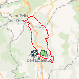

Length
14.1 km

Max alt
736 m

Uphill gradient
581 m
Km-Effort
22 km

Min alt
301 m

Downhill gradient
580 m
Boucle
Yes
Creation date :
2017-03-24 00:00:00.0
Updated on :
2017-03-24 00:00:00.0
4h35
Difficulty : Medium

FREE GPS app for hiking
 SityTrail
IGN / Geographical institutes
SityTrail Plus
The world is yours!
About
Trail Walking of 14.1 km to be discovered at Occitania, Hérault, Pégairolles-de-l'Escalette. This trail is proposed by vertygo.
Description
voir des photos et d'autres parcours sur www.vertygo.org
https://goo.gl/photos/Qiayjt4MQgTrWxte8


Positioning
Country:
France
Region :
Occitania
Department/Province :
Hérault
Municipality :
Pégairolles-de-l'Escalette
Location:
Unknown
Start:(Dec)
Start:(UTM)
526005 ; 4849809 (31T) N.
Comments