


compiegne 17/261

les randos d'Olivier
partout a pied et en moto
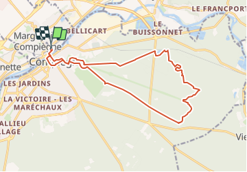

Length
16.8 km

Max alt
149 m

Uphill gradient
254 m
Km-Effort
20 km

Min alt
31 m

Downhill gradient
254 m
Boucle
Yes
Creation date :
2024-01-07 18:02:41.594
Updated on :
2024-01-08 06:08:57.476
4h35
Difficulty : Very difficult

FREE GPS app for hiking
 SityTrail
IGN / Geographical institutes
SityTrail Plus
The world is yours!
About
Trail Walking of 16.8 km to be discovered at Hauts-de-France, Oise, Margny-lès-Compiègne. This trail is proposed by les randos d'Olivier.
Positioning
Country:
France
Region :
Hauts-de-France
Department/Province :
Oise
Municipality :
Margny-lès-Compiègne
Location:
Unknown
Start:(Dec)
Start:(UTM)
487197 ; 5474368 (31U) N.
Comments