


pilone

ninia
User
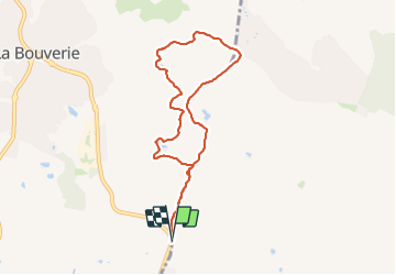

Length
8.1 km

Max alt
97 m

Uphill gradient
98 m
Km-Effort
9.4 km

Min alt
52 m

Downhill gradient
97 m
Boucle
Yes
Creation date :
2024-01-08 08:05:33.474
Updated on :
2024-01-08 10:48:41.641
2h42
Difficulty : Easy

FREE GPS app for hiking
 SityTrail
IGN / Geographical institutes
SityTrail Plus
The world is yours!
About
Trail Walking of 8.1 km to be discovered at Provence-Alpes-Côte d'Azur, Var, Roquebrune-sur-Argens. This trail is proposed by ninia.
Positioning
Country:
France
Region :
Provence-Alpes-Côte d'Azur
Department/Province :
Var
Municipality :
Roquebrune-sur-Argens
Location:
Unknown
Start:(Dec)
Start:(UTM)
311210 ; 4816702 (32T) N.
Comments