


2024-01-08-fexlix-lagni-cabredor Parcourue

Christianlabourie
User
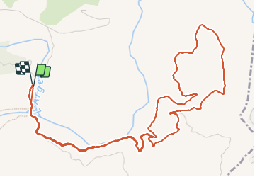

Length
8.3 km

Max alt
176 m

Uphill gradient
202 m
Km-Effort
10.9 km

Min alt
30 m

Downhill gradient
195 m
Boucle
Yes
Creation date :
2024-01-08 13:04:33.012
Updated on :
2024-01-09 17:20:06.232
2h29
Difficulty : Medium

FREE GPS app for hiking
 SityTrail
IGN / Geographical institutes
SityTrail Plus
The world is yours!
About
Trail Walking of 8.3 km to be discovered at Provence-Alpes-Côte d'Azur, Var, Les Arcs-sur-Argens. This trail is proposed by Christianlabourie.
Description
sans aucune difficculté. Dénivele très bien réparti.
Positioning
Country:
France
Region :
Provence-Alpes-Côte d'Azur
Department/Province :
Var
Municipality :
Les Arcs-sur-Argens
Location:
Unknown
Start:(Dec)
Start:(UTM)
298527 ; 4812052 (32T) N.
Comments