


Wikiloc - Lee trail

collignpn
User GUIDE
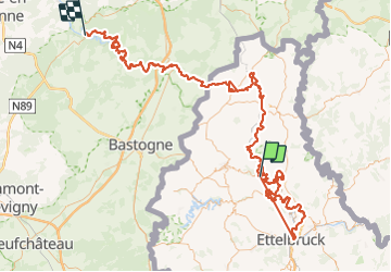

Length
181 km

Max alt
513 m

Uphill gradient
6473 m
Km-Effort
268 km

Min alt
194 m

Downhill gradient
6516 m
Boucle
No
Creation date :
2024-01-09 15:38:03.545
Updated on :
2024-01-09 15:38:55.83
60h47
Difficulty : Very difficult

FREE GPS app for hiking
 SityTrail
IGN / Geographical institutes
SityTrail Plus
The world is yours!
About
Trail On foot of 181 km to be discovered at Unknown, Canton Wiltz, Kiischpelt. This trail is proposed by collignpn.
Positioning
Country:
Luxembourg
Region :
Unknown
Department/Province :
Canton Wiltz
Municipality :
Kiischpelt
Location:
Unknown
Start:(Dec)
Start:(UTM)
286196 ; 5537320 (32U) N.
Comments