


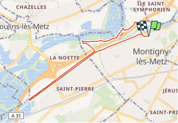
Canal de la Moselle 8 km BS

bstebe
User

Length
8.3 km

Max alt
174 m

Uphill gradient
44 m
Km-Effort
8.9 km

Min alt
161 m

Downhill gradient
44 m
Boucle
Yes
Creation date :
2024-01-10 10:18:52.196
Updated on :
2024-01-10 10:20:08.678
2h01
Difficulty : Medium

FREE GPS app for hiking
 SityTrail
IGN / Geographical institutes
SityTrail Plus
The world is yours!
About
Trail Walking of 8.3 km to be discovered at Grand Est, Moselle, Montigny-lès-Metz. This trail is proposed by bstebe.
Positioning
Country:
France
Region :
Grand Est
Department/Province :
Moselle
Municipality :
Montigny-lès-Metz
Location:
Unknown
Start:(Dec)
Start:(UTM)
292138 ; 5442968 (32U) N.
Comments