


voie verte

rousseau.mich
User

Length
10.9 km

Max alt
101 m

Uphill gradient
101 m
Km-Effort
12.3 km

Min alt
56 m

Downhill gradient
100 m
Boucle
Yes
Creation date :
2015-03-01 00:00:00.0
Updated on :
2015-03-01 00:00:00.0
2h04
Difficulty : Unknown

FREE GPS app for hiking
 SityTrail
IGN / Geographical institutes
SityTrail Plus
The world is yours!
About
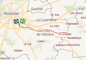
Trail Walking of 10.9 km to be discovered at Brittany, Morbihan, Ploërmel. This trail is proposed by rousseau.mich.
Positioning
Country:
France
Region :
Brittany
Department/Province :
Morbihan
Municipality :
Ploërmel
Location:
Ploërmel
Start:(Dec)
Start:(UTM)
545876 ; 5307547 (30T) N.
Comments