


aaa

ARPF
User

Length
16.6 km

Max alt
798 m

Uphill gradient
757 m
Km-Effort
27 km

Min alt
395 m

Downhill gradient
756 m
Boucle
Yes
Creation date :
2015-03-01 00:00:00.0
Updated on :
2015-03-01 00:00:00.0
5h26
Difficulty : Difficult

FREE GPS app for hiking
 SityTrail
IGN / Geographical institutes
SityTrail Plus
The world is yours!
About
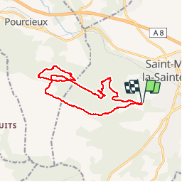
Trail Walking of 16.6 km to be discovered at Provence-Alpes-Côte d'Azur, Var, Saint-Maximin-la-Sainte-Baume. This trail is proposed by ARPF.
Description
Louis le 01/03/2015, par temps gris.
Positioning
Country:
France
Region :
Provence-Alpes-Côte d'Azur
Department/Province :
Var
Municipality :
Saint-Maximin-la-Sainte-Baume
Location:
Unknown
Start:(Dec)
Start:(UTM)
730054 ; 4813677 (31T) N.
Comments