


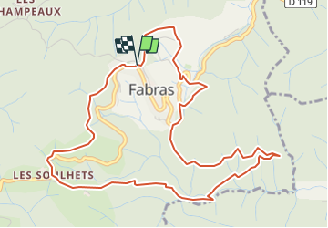
Fabras

Rudy07
User

Length
6.3 km

Max alt
520 m

Uphill gradient
231 m
Km-Effort
9.4 km

Min alt
324 m

Downhill gradient
232 m
Boucle
Yes
Creation date :
2024-01-11 15:23:37.423
Updated on :
2024-01-25 08:05:32.544
2h07
Difficulty : Easy

FREE GPS app for hiking
 SityTrail
IGN / Geographical institutes
SityTrail Plus
The world is yours!
About
Trail Walking of 6.3 km to be discovered at Auvergne-Rhône-Alpes, Ardèche, Fabras. This trail is proposed by Rudy07.
Positioning
Country:
France
Region :
Auvergne-Rhône-Alpes
Department/Province :
Ardèche
Municipality :
Fabras
Location:
Unknown
Start:(Dec)
Start:(UTM)
602163 ; 4945043 (31T) N.
Comments