


Juvinas

Rudy07
User

Length
10.3 km

Max alt
773 m

Uphill gradient
455 m
Km-Effort
16.4 km

Min alt
498 m

Downhill gradient
454 m
Boucle
Yes
Creation date :
2024-01-11 15:39:17.812
Updated on :
2024-02-28 18:53:35.514
3h43
Difficulty : Difficult

FREE GPS app for hiking
 SityTrail
IGN / Geographical institutes
SityTrail Plus
The world is yours!
About
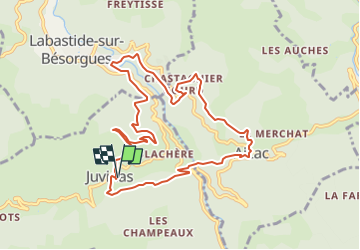
Trail Walking of 10.3 km to be discovered at Auvergne-Rhône-Alpes, Ardèche, Juvinas. This trail is proposed by Rudy07.
Positioning
Country:
France
Region :
Auvergne-Rhône-Alpes
Department/Province :
Ardèche
Municipality :
Juvinas
Location:
Unknown
Start:(Dec)
Start:(UTM)
603551 ; 4951647 (31T) N.
Comments