


2024.01.11 - La Montagnette

rando30129
User
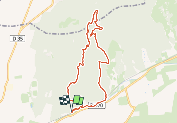

Length
11.1 km

Max alt
151 m

Uphill gradient
219 m
Km-Effort
14 km

Min alt
11 m

Downhill gradient
218 m
Boucle
Yes
Creation date :
2024-01-11 12:35:07.0
Updated on :
2024-01-11 15:56:55.385
3h21
Difficulty : Difficult

FREE GPS app for hiking
 SityTrail
IGN / Geographical institutes
SityTrail Plus
The world is yours!
About
Trail Walking of 11.1 km to be discovered at Provence-Alpes-Côte d'Azur, Bouches-du-Rhône, Tarascon. This trail is proposed by rando30129.
Positioning
Country:
France
Region :
Provence-Alpes-Côte d'Azur
Department/Province :
Bouches-du-Rhône
Municipality :
Tarascon
Location:
Unknown
Start:(Dec)
Start:(UTM)
636358 ; 4853875 (31T) N.
Comments