Montagnards alouettes chères

ophness
User
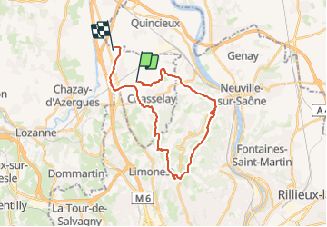

Length
27 km

Max alt
593 m

Uphill gradient
619 m
Km-Effort
35 km

Min alt
179 m

Downhill gradient
646 m
Boucle
No
Creation date :
2024-01-12 09:46:14.0
Updated on :
2024-01-12 09:46:15.583

FREE GPS app for hiking
 SityTrail
IGN / Geographical institutes
SityTrail Plus
The world is yours!
About
Trail of 27 km to be discovered at Auvergne-Rhône-Alpes, Rhône, Chasselay. This trail is proposed by ophness.
Positioning
Country:
France
Region :
Auvergne-Rhône-Alpes
Department/Province :
Rhône
Municipality :
Chasselay
Location:
Unknown
Start:(Dec)
Start:(UTM)
636555 ; 5082566 (31T) N.
Comments