


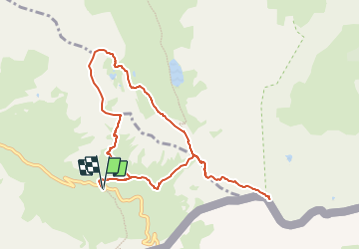
Queyras: Pic Foréant et Pain de Sucre

MathieuBourgois
User

Length
10.1 km

Max alt
3158 m

Uphill gradient
899 m
Km-Effort
22 km

Min alt
2567 m

Downhill gradient
900 m
Boucle
Yes
Creation date :
2024-01-12 11:38:31.627
Updated on :
2024-01-12 11:38:58.266
5h00
Difficulty : Medium

FREE GPS app for hiking
 SityTrail
IGN / Geographical institutes
SityTrail Plus
The world is yours!
About
Trail On foot of 10.1 km to be discovered at Provence-Alpes-Côte d'Azur, Hautes-Alpes, Molines-en-Queyras. This trail is proposed by MathieuBourgois.
Description
10km 900D
Positioning
Country:
France
Region :
Provence-Alpes-Côte d'Azur
Department/Province :
Hautes-Alpes
Municipality :
Molines-en-Queyras
Location:
Unknown
Start:(Dec)
Start:(UTM)
339239 ; 4950682 (32T) N.
Comments