


12/01/2024 _ De Brigneau Nord à l'Ile Percée et Trénez.Virtuel

babeth35
User
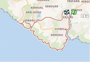

Length
10.5 km

Max alt
33 m

Uphill gradient
116 m
Km-Effort
12 km

Min alt
0 m

Downhill gradient
116 m
Boucle
Yes
Creation date :
2024-01-12 16:28:53.668
Updated on :
2024-01-12 16:45:51.175
2h44
Difficulty : Easy
2h44
Difficulty : Difficult

FREE GPS app for hiking
 SityTrail
IGN / Geographical institutes
SityTrail Plus
The world is yours!
About
Trail On foot of 10.5 km to be discovered at Brittany, Finistère, Moëlan-sur-Mer. This trail is proposed by babeth35.
Positioning
Country:
France
Region :
Brittany
Department/Province :
Finistère
Municipality :
Moëlan-sur-Mer
Location:
Unknown
Start:(Dec)
Start:(UTM)
449949 ; 5293331 (30T) N.
Comments